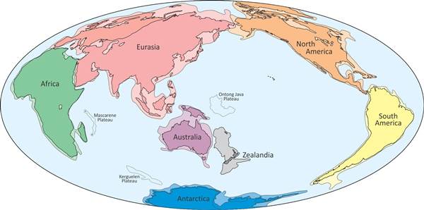
World News – Scientists say they have identified an underwater continent two-thirds the size of Australia — and they are calling it Zealandia.
This newly proposed continent is about 1.74 million square miles in size and 94 percent submerged. But at its highest points, it protrudes above the ocean surface in the form of New Zealand and New Caledonia, according to a paper published in GSA Today, the journal of the Geological Society of America.
The proposed recognition of the continent of Zealandia does not represent the discovery of a new land mass. Rather, the paper argues that the geological evidence suggests the land mass should be classified not as a collection of islands and fragments but as a bona fide continent.
“If we could pull the plug on the oceans, it would be clear to everyone we have mountain chains and a big, high-standing continent above the ocean crust,” Nick Mortimer, a geologist at GNS Science in Dunedin, New Zealand, told Reuters.
Mortimer was the lead author of the paper, “Zealandia: Earth’s Hidden Continent.”
New discoveries about the geology of the region prove what has long been suspected, he said.
“Since about the 1920s, from time to time in geology papers people used the word ‘continental’ to describe various parts of New Zealand and the Catham Islands and New Caledonia,” Mortimer said.
“The difference now is that we feel we’ve gathered enough information to change ‘continental’ to the noun ‘continent,'” he added.
The land mass meets the geological definition of a continent, according to the paper. It has high elevation compared to the ocean crust. It has certain geological components, including a crust thicker than ocean crust. And it has well-defined limits around an area large enough to be considered a continent rather than a fragment.
Zealandia is believed to have broken away from Australia about 80 million years ago and sunk beneath the sea as part of the break-up of the super-continent Gondwanaland.
By contrast, modern human beings are believed to have emerged only about 200,000 years ago.
Mortimer recognizes that the paper at this point represents the making of a geological case — the opening of an argument rather than its resolution.
“The litmus test will really be if Zealandia appears in maps and atlases in five or 10 years time,” he said.
by DON MELVIN, NBCNews.com

